Someone you know complaining they don’t have enough to do this summer? Tell them to take a hike. Literally. Summer is the perfect time to go hiking and explore the United States. The US is a pretty big place, with tons of opportunities for hiking and camping in beautiful spots.
Whatever your interest may be, make this summer a stand-out with a hike you’ve never done before. And be sure to pack more water than you think you’ll need, as well as extra layers for temperature fluctuations. With that, check out these trails!
| Glacier Point | Beginner | Yosemite | CA |
| Bridalveil Falls | Beginner | Yosemite | CA |
| Rachel Lake and Rampart Lake | Advanced | Alpine Lakes Wilderness | WA |
| Cape Lookout Trail | Beginner | Cape Lookout State Park | OR |
| Mount Rose | Advanced | Mount Rose Wilderness | NV |
| Goldstrike Hot Springs | Advanced | Nevada / Arizona Border | NV |
| The Goblin’s Lair | Advanced | Goblin Valley State Park | UT |
| Curtis Bench Trail | Moderate | Goblin Valley State Park | UT |
| Sawtooth Lake | Moderate | Sawtooth Mountains | ID |
| Tubbs Hill Trail | Beginner | Tubbs Hill Park | ID |
| Fern Canyon | Moderate | Prairie Redwoods State Park | CA |
| Ewoldsen Trail | Moderate | Big Sur | CA |
 GLACIER POINT – YOSEMITE, CA
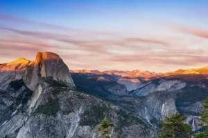 GLACIER POINT – YOSEMITE, CA
Difficulty: Beginner
This one-mile hike gains almost zero elevation over its length from a nearby trailhead.
You’ll enjoy a brief hike at 7,000 ft to Glacier Point which is, arguably, one of the highest real-estate views on the West Coast.
Treat yourself to views of Vernal and Nevada Falls, North Dome and Royal Arches, Yosemite Falls, and the iconic Half Dome.
Stay for the evening sunset talk with a National Park ranger for some great natural history and interpretive talk.
Pro Tip: Start planning and hit this hike during peak snow melt in early spring to take full advantage of swollen flow rates on the falls for the best views.
Be warned, however, that the access road to the trailhead is closed until season weather passes; you’ll need skis if you’re going in too early.
BRIDALVEIL FALLS – YOSEMITE, CA
Difficulty: Beginner
While you’re in Yosemite do yourself a favor and go visit this Ansel Adams favorite. Don’t forget to bring your camera to replicate those legendary black and white photos.
Much like Glacier Point, visiting during peak snow melt is advised for maximum impression.
Pro Tip: Bring rain gear to stave off the torrents of soaking mist during peak run off and watch out for the slippery water-soaked rocks along the trail.
Try to hit this one in between the tour bus stops as the crowds will fluctuate in accordance with their schedules.
RACHEL LAKE AND RAMPART LAKE – ALPINE LAKES WILDERNESS, WA
Difficulty: Advanced
Prepare to plunge into the true wilderness; a public land designation issued by Congress which prevents any development, signage, or motorized vehicles among other things.
You’ll want to prepare for this hike with appropriate equipment and potential overnight supplies just in case. During the nicer months, however, you’ll find that this hike is a surprisingly frequented overnight destination for quick getaways so you’ll have company.
Serious stretches of elevation gain (more than 1200 feet in a single stretch) mean you’ll want to be prepared for a higher level of physical activity than the previous hikes.
This hike is known for its breathtaking fall colors and autumn experience. Enjoy the crimson and gold reflections of the changing seasons as the sun sets across the lake.
Pro Tip: Be sure to understand Leave No Trace principles for backcountry travel and camping to help minimize your impact on this much-loved natural destination.
CAPE LOOKOUT TRAIL – CAPE LOOKOUT STATE PARK, OR
Difficulty: Beginner
Crush this 5-mile trail with amazing views of the Oregon coast with a quick yo-yo hike (there and back).
Be aware that because of easy access and amazing scenery this trail is often quite congested.
Take your time wandering the trail as it pops in and out of the dense northern rainforest and coastal cliffs.
Head back along the trail and spend the night at the campground here in Cape Lookout State Park, a very well-curated space you’ll love to stay at.
Pro Tip: Get started before sunrise and take your headlamp to enjoy the trail free of other hikers. You’ll get to experience a part of the world few others have seen at a time when everyone else is asleep.
MOUNT ROSE – MOUNT ROSE WILDERNESS, NV
Difficulty: Advanced
Turning our attention inland we’re going to take a quick job to Reno, Nevada.
Mt Rose is relatively easy to access, just a few miles outside of Reno proper along 431 you’ll hike north into a true wilderness.
Climbing this ancient volcano will afford great views of Lake Tahoe along the way as you ascend over 1700ft to earn the summit.
With easy access and a front country relatively nearby this hike earns “advanced” difficulty due to the 10-mile length and aggressive ascent.
If you’re looking to bag a 10,000 ft peak on a challenging day hike then this is a hike just for you!
Pro Tip: Hike in early summer to take advantage of still-cool weather and remaining patches of high elevation snow melt for water sources on this long hike. Don’t forget to pack plenty of food to cover the out and back hike.
GOLDSTRIKE HOT SPRINGS – NEVADA / ARIZONA BORDER
Difficulty: Advanced
Get ready for some canyoneering on this technical 7-mile hike in the sandstone washes of Nevada.
Be certain to familiarize yourself with canyon travel techniques and bring appropriate equipment on this adventurous hike into the deep wilderness of Nevada.
You’ll be rewarded for some climbing, scrambling, and canyoneering with several hot spring pools. Beware of wet boots and slipping on the canyon rocks.
Wear canyoneering-specific footwear; hybrid hiking/climbing shoes provide the best grip for canyoneering and are made specifically for the sport.
Hike all the way to the end to enjoy a view of the Colorado river which marks the boundary between Arizona and Colorado.
Some of these once-beautiful springs have now dried up so you may, sadly, find that the Colorado River is the true prize of your journey.
Return up the same canyon you descended for a yo-yo hike.
Pro Tip: Canyoneering can be dangerous and technical. This route is relatively simple but we recommend that you seek higher level training if adventuring out into other canyons.
Hike in the spring and fall but watch out for flash flooding during surprise storms. There’s no way out of a flooding canyon. Summer heat can make for a dangerous or fatal hike.
THE GOBLIN’S LAIR – GOBLIN VALLEY STATE PARK, UT
Difficulty: Advanced
Earning an advanced difficulty rating due to its remote location, and desert conditions, this otherwise easy hike is sure to impress.
Be sure to top off on gas before entering the San Rafael Swell and carry an extra can of gas in the truck. You’ll want to leave the compact car behind to access this remote and rugged landscape.
Take several extra gallons of water in the vehicle because you can be sure there won’t be any out here.
Follow the Carmel Canyon hiking loop for half a mile and then turn down the marked trail for the Goblin’s Lair.
Find your way into the entrance of this now-blocked slot canyon and time it just right to enjoy the spectacle of light rays beaming through gaps in the canyon ceiling a hundred feet above you.
Slot canyoneering is dangerous, highly technical, and sometimes fatal to those who are not expertly trained.
Don’t be tempted to try to find your way deeper into this technical canyon but instead head back and enjoy the myriad of other Goblin Valley hiking trails.
Goblin Valley has a camping area so check in with the visitor center for camping information.
Pro Tip: Get started by headlamp before dawn to avoid the hot times of the day. Avoid hiking this area altogether during the peak heat of summer as the weather can be fatal to those unprepared.
Know where you are going? Buy your hiking gear here now!
CURTIS BENCH TRAIL – GOBLIN VALLEY STATE PARK, UT
Difficulty: Moderate
We’ll call this one “moderate” because, while still remote and desert, there aren’t any canyons involved.
Enjoy the opposite vantage point of the San Rafael with higher elevation and views of the surrounding desert landscape.
You’ll be rewarded with an overhead view of the Valley of Goblins, a sandstone monument scattered area unique like no others.
Beautiful views of the surrounding mountains will leave you appreciating this unique desert landscape. Striated sandstone bands surround your hike and you’ll find yourself suddenly becoming very aware that you might just be walking on Mars.
Pro Tip: See the pro tips from Goblin’s Lair and do a little research on the geology of the area before heading in. You’ll be amazed at exactly what you’re seeing: many of the geological features are nearly identical to those found on Mars.
SAWTOOTH LAKE – SAWTOOTH MOUNTAINS, ID
Difficulty: Moderate
Hike 8.5 miles round trip and grab a quick 1,700 ft of vertical as a warmup for your cardio-kicking legs.
Idaho’s Sawtooth range is known for abrupt, jagged, and barren slopes.
You’ll want to make sure to pack the DSLR for some seriously kick-ass photos of this alpine lake on a still morning.
Plan your hike for a nice calm-weather day and get an early start to grab the best photos before the morning sun begins to warm the mountain air and produce convective winds.
You’ll find this trail to be well-loved and sometimes congested so an off-season hike or, as before, an early start is recommended.
Pro Tip: Going for great photos? Be ready to do a little non-technical scrambling to find the best vantage points. Take a good backpack to protect your camera equipment as you’ll need both hands free to navigate the scree-covered slopes.
TUBBS HILL TRAIL – TUBBS HILL PARK, ID
Difficulty: Beginner
Nearly flat, this 2.5-mile hike lazily circles a pine-forested lake near Coeur d’ Alene.
Accessible from June to September you can take Fido along on this relaxing short hike. Dogs are welcome here so grab the hammock and sling it up with the dog to enjoy a siesta along the lake in mid-summer.
Easy access to water, a short route, and mild northern weather make this a hike for any time of year.
You’ll need winter traveling skills if you plan to go in here during the winter months so shoot for early or late summer.
Pro Tip: Take a book, sandals, and a hammock with you to properly enjoy this hike. Find yourself a great resting spot and while away the day in true mountain fashion.
 FERN CANYON – PRAIRIE REDWOODS STATE PARK, CA
 FERN CANYON – PRAIRIE REDWOODS STATE PARK, CA
Difficulty: Moderate
You’ll feel as if you’ve stepped into some kind of pre-historic forest on this 9-mile hike.
Start at the visitor center in the Prairie Redwoods State Park and talk to the rangers to get your map and directions.
It will be well worth the 9-mile round trip hike to find your way down into this otherworldly setting as you navigate through deep redwood and fir-dominated forests.
Don’t forget to bring a camera along because you’ll be experiencing a once-in-a-lifetime type of deep and immersive flora.
You might feel as if this easy meandering trail has transported you to Jurassic Park, but don’t worry, T-Rex won’t find you.
Pro Tip: Don’t tell your hiking partner about the Fern Canyon parking lot which is located very close to Fern Canyon itself. They’ll be glad you tricked them into making this longer, but rewarding hike.
EWOLDSEN TRAIL – BIG SUR, CA
Difficulty: Moderate
Somewhere between a beginner trail and an advanced trail, this 4.5-mile loop will take you through the whole gamut of Big Sur terrain.
Expect a 1,600 ft climb in elevation and varying trail conditions.
Bundle this hike together with the McWay Falls trail which also starts from the same parking lot in order to really maximize your day.
You’ll be treated to canyon views and plunged into deep redwood forests during this all-encompassing hike through just about everything the area has to offer.
An optional short side trail will take you up to great views of the nearby waterfall.
Pro Tip: Pack light and eat lunch back in the parking lot. It’s easy to make this 4.5-mile round-trip hike in under two hours. Don’t forget to slow down, however, and enjoy the views as you meander along.